
Page 32 - Volume 15 Number 12
P. 32
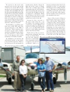
We arrived on the dock early and motored out into the mouth of the bay in a tired old boat that was heavy as a lead sinker and old enough to have grandkids. We spent the day harvesting halibut from the nearly 200 foot deep water. Halibut taste much better than they look, and while we weren’t catching big fish, we brought in a nice stringer of good eaters that we had cleaned, flash frozen, and shipped home 10 days later, when we returned.We filed IFR to cross Witter pass that was solidly IMC and were cleared directly to the MEA of 11,000 feet. Thirty minutes later, we broke out just south of Valdez and Prince William Sound, where we were treated to a spectacular view of the glaciers and coastal mountains of Southeast Alaska.Mt. McKinley is 20,320 feet tall and known widely as the tallest rock in North America. What is less known are the mountains inThe group upon its return to MCWSoutheastern Alaska. Mount St. Elias sits in the corner of Alaska, where the coastline turns south towards the lower 48. At 18,008 feet, when viewed from the perspective of sea level, Mt. St. Elias is every bit as impressive as McKinley. Think about flying at 11,000 feet and looking at a mountain that reaches nearly twice as far to the sky.Passing Icy Bay, en-route to the turn south down the coast at Yakutat, the weather cleared completely, and the METAR and forecast for Sitka were holding up well, so we cancelled IFR and let down for some sightseeing along Glacier Bay National Park.Nearly as far as the eye can see, glaciers were calving into the oceanRussian settlement that dates back hundreds of years, to a time when the Russians were trading with the natives. The airport is an island that resembles an aircraft carrier with water on both ends of the runway, but the facilities were modern and the amenities were nice.Some of the secrets to flying in the North are: Never get in a hurry. Wait on the weather. Always have a contingency plan. And be flexible. Our plan was to fly up the Highway and down the coast. But, from the beginning, we were prepared to modify that if needed. There were several key decision points and Sitka was one of them. The weather on the Pacific Coast can be horrible. If it was bad, one of the divert plansor into pools that drain into the surf. Glaciers gave way to coastal islands and communities started to appear as we moved southward. Sitka is aPhotos by Doug RozendaalThe route (on AOPA Internet Flight Planner)30 • TWIN & TURBINEDECEMBER 2011
